California Trail - Salt Lake Cutoff

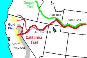
The California Trail followed a variety of routes from 1840 until the 1870's when the railroad became the faster and more reliable way to reach the Sacramento Valley and other destinations west of the Sierra Nevada Mountains. The first emigrants to attempt a northern route were the Bidwell Party in 1841 (the Old Spanish Trail from Santa Fe to San Gabriel Mission and Los Angeles had been in use since 1829). Bidwell led his group from Sheep Rock, on the future Oregon Trail, down Bear River to the Great Salt Lake which he passed on the north and traversed many miles of desert before finally reaching The Humbolt River in present day Nevada (see my posting titled Bear River).
Six years later, the Hastings Party followed Echo and Weber Canyons into the Salt Lake Valley and from there crossed the desert south of The Great Salt Lake. They were followed that same year by the Donner-Reed Party who went from Echo Canyon through East And Emigrant Canyons where they experienced great hardship in reaching the Salt Lake Valley. they also crossed the desert south of the Great Salt Lake and were so delayed in their journey that they hit the Sierras in winter where many of them died (see my posting Crossing the Wasatch).


The difficulties these early parties faced crossing The Great Salt Lake Desert made the development of an alternate route imperative. This was achieved with the discovery of Granite Pass near City of Rocks and Almo, Idaho. By the time of the 49er gold rush, California bound travelers had a choice of routes. They could follow the Oregon Trail to the junction of the Raft and Snake Rivers, west of Fort Hall, Oregon Territory, and then follow Raft River to Granite Pass. As an alternative, they could come into The Salt Lake Valley and follow the Salt Lake Cutoff to the same destination. By the 1880's over 200,000 emigrants had passed through City of Rocks on their way to California and many had chosen the Salt Lake Cutoff as their route.
From the Salt Lake Valley, the travelers, whether gold seekers or farmers, would travel north along the west side of the Wasatch range. This is well watered by rivers and creeks that flow to the lake and would have been relatively easy traveling. When they reached the Hampton Ford on The Bear River (see my posting Bear River), they would cross into the arid Great Basin and be dependent on springs until reaching City of Rocks.
Fortunately for me, I was able to take Interstate 84 to Snowville, Utah where I exited to US 30 which follows the trail for several miles. Where 30 heads south toward Elko, Nevada I transitioned to gravel roads which I followed the rest of the way.

This is pretty country but quite empty although where the road was paved there was an almost constant succession of ranches.

Cattle are plentiful but obvious sources of water are scarce. I'm sure the ranches depend on springs and runoff from the mountains.

After over sixty miles of gravel road, I made it to City of Rocks, a gathering place for emigrants on their way to Granite Pass.

Today, the granite formations are a favorite climbers' destination but for the California bound travelers they were a curiosity and a place to leave record of their passing.
I have referred to this area as arid but the modern ranches testify to the abundance and quality of grass. By the time they reached City of Rocks the wagons could spread out and allow their animals to graze and regain their strength.


One of the more dramatic formations is Twin Sisters.

From City of Rocks the trail heads to Granite Pass and Nevada. It's over 9000 feet but a fairly easy climb from here.


When I reached the Snake River Plain near Burley, Idaho, it was time to head northwest on the Oregon Trail where I will continue in another post.
From the Salt Lake Valley, the travelers, whether gold seekers or farmers, would travel north along the west side of the Wasatch range. This is well watered by rivers and creeks that flow to the lake and would have been relatively easy traveling. When they reached the Hampton Ford on The Bear River (see my posting Bear River), they would cross into the arid Great Basin and be dependent on springs until reaching City of Rocks.
 |
| The Sagebrush Sea west of Snowville. UT |
Fortunately for me, I was able to take Interstate 84 to Snowville, Utah where I exited to US 30 which follows the trail for several miles. Where 30 heads south toward Elko, Nevada I transitioned to gravel roads which I followed the rest of the way.

This is pretty country but quite empty although where the road was paved there was an almost constant succession of ranches.

Cattle are plentiful but obvious sources of water are scarce. I'm sure the ranches depend on springs and runoff from the mountains.

After over sixty miles of gravel road, I made it to City of Rocks, a gathering place for emigrants on their way to Granite Pass.

Today, the granite formations are a favorite climbers' destination but for the California bound travelers they were a curiosity and a place to leave record of their passing.
 |
| The signatures on the rocks are fading but still visible. |
I have referred to this area as arid but the modern ranches testify to the abundance and quality of grass. By the time they reached City of Rocks the wagons could spread out and allow their animals to graze and regain their strength.


One of the more dramatic formations is Twin Sisters.

From City of Rocks the trail heads to Granite Pass and Nevada. It's over 9000 feet but a fairly easy climb from here.


 |
| Wagon ruts heading to Granite Pass |
There is a secondary road to the pass but it crosses private ground and is labeled "rough road" so I decided to leave it for another time. Instead, I headed back north to where the trail connects with the Oregon Trail. On the way I passed the junction of the trail with the road used by the Kelton-Boise Overland Stage Line which connected the Central Pacific Railroad to Boise after 1869.


A few miles north of City of Rocks, I crossed a low divide into the Raft River drainage which continues to the Snake River.

The Raft River is small but this is nice country with a lot of grass and cows, also nice views.

I have crossed Raft River many times farther north and it never gets much bigger that this.
 |
| Raft River Mountains |

When I reached the Snake River Plain near Burley, Idaho, it was time to head northwest on the Oregon Trail where I will continue in another post.


Comments
Post a Comment