The Oregon Trail in Idaho and Oregon
This is the third in a series of related posts on the Oregon Trail. The first two are The Oregon Trail, Fort Kearny to Fort Bridger, and The Oregon/California Trail: Fort Bridger to Fort Hall. I appreciate your comments and feedback.
Click on the pictures for full screen
Click on the pictures for full screen

Fur traders were using different sections of the Oregon Trail as early as 1812 when New Yorker John Jacob Astor established Astoria at the mouth of the Columbia and needed an overland route to the east. Astor's competitors, The Hudson's Bay Company (British) and later, the Rocky Mountain Fur Company (United States) established trading posts along the route from Missouri to the Willamette Valley, at Fort Boise, near the confluence of the Snake and Owyhee Rivers, Fort Hall on the upper Snake River, and Fort Laramie on the North Platte River.

In modern times, we tend to focus on the mystique of the mountain man trappers of this era but perhaps more important to the opening of western routes were the traders and explorers who pioneered the trails. General Ashley and Jedediah Smith, of the Rocky Mountain Fur Company, developed the routes from the upper North Platte to the Upper Snake River and the far western trails were largely explored by employees of the Hudson's Bay Company (ironically mostly French Canadians).
The first real emigrants to Oregon from the U.S. were the members of the Whitman-Spalding party in 1836, whose mission was to bring Christianity and sedentary agriculture to the Indians. They first arrived at Fort Vancouver but later the Whitmans relocated to the Walla Walla Valley where they were killed in a Indian raid.
Hard economic times in the States during the late 1830's and early 40's stimulated interest in moving west and in 1843 a thousand people braved The Oregon Trail. Over the next forty years they were joined by an additional 400,000.


 |
| Fort Hall Replica |
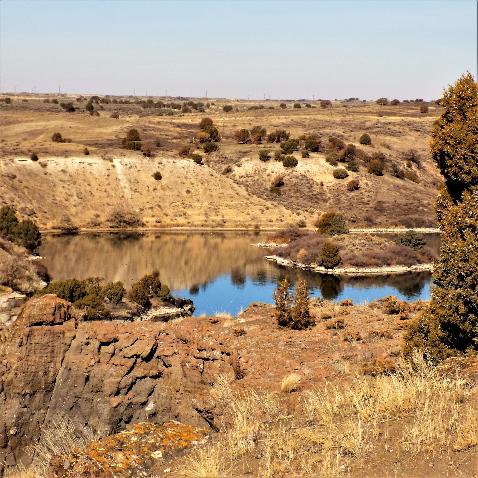
After leaving Fort Hall, near present day Pocatello, Idaho, the wagon trains followed the left (south) bank of The Snake River. The left bank is relatively open country through this first leg while the right bank is volcanic cliffs. The first notable landmark is American Falls which has now been flooded by the most recent in a succession of hydro dams.
 |
| American Falls Dam |
 |
| American Falls Reservoir |
In mid-fall the river below the dam is low and sluggish.
 |
| Shoals along Snake River below American Falls Dam |
Progressing southwest, the trail enters rougher country and the river passes through canyons that provided good spots for Indian ambushes. Initially tolerant, and even helpful, to the emigrants, the western Shoshone became increasingly resentful of incursions into their lands and increasingly willing to express resentment violently.


The steep banks of the river along this stretch made travelers bunch up and the rocky ground provided cover for ambush.
Eventually the trail passes through Massacre Rocks.
 |
| Massacre Rocks |

Massacre Rocks State Park extends down river to more open land where there is a boat launching site.


Nearby Register Rock is a disappointment because the rock with its inscriptions is covered by a shed roof and completely wrapped in chain link fencing.

It's easy to see, however, why this was a popular camping spot. A swiftly flowing stream enters the river here and provides water for a pleasant (and rare) grove of mixed juniper and cottonwoods.
After Register Rock the trail rapidly approaches the Parting of the Ways, where travelers bound for California turned south toward City of Rocks and Granite Pass.


California bound emigrants followed the Raft River Valley south across flat, easily traveled country.

Even at its confluence with The Snake River, Raft River is little more than a dry ditch but it must, at one time, formed something of an inland delta here as the valley is wide and flat. There is irrigated agriculture here but further south it is all grazing land.
 |
| Grazing allotment in Raft River Valley |

My post California Trail, Salt Lake Cutoff contains more information on City Of Rocks and Granite Pass. You can read there what faced those travelers bound for California. As for those heading to Oregon, their next landmark, and obstacle, was Twin Falls. The Minidoka Dam upstream has done much to reduce the flow at Twin Falls but the gorge is still formidable and the surrounding land is dry and rocky.
 |
| Twin Falls Gorge on Snake River. |
West of Twin Falls, the left bank of the river opens up into a valley that stays level with the riverbank while the right bank remains a cliff. This area is called Thousand Springs because of the springs that shoot out of the porous cliff faces.

In the early days of the trail, there were several ferries at work in this area at different times. The travelers liked to cross to what was considered the easier side. Today, this makes no sense because the left bank has no cliffs for many more miles. Dams and agriculture have no doubt changed the geography a great deal but this seems like a much more pleasant area to me.


This may have been a popular crossing area because it was a fishing area heavily used by the Indians and there were many well used trails to access the river. There was also a falls here, since lost to downstream damming which drew the Indians to establish seasonal fishing camps.

The road west from Thousand Springs to Bliss is scenic and well watered on the flood plain which is bracketed by volcanic cliffs. The plain above is mostly sagebrush except where irrigation is in use.


This area is near the Hagerman Fossil Beds national Monument. From here, the highway remains along the river but the original trail cuts across country to Glenn's Ferry which in the later days of travel became a favorite crossing of Snake River.

In the early days of the Willamette bound emigrants, the travelers caulked their wagons with their clothes and towed them across the river using the islands here as stepping stones. Later on, several commercial ferries operated here to service emigrants, freight haulers and the overland stage to Boise.
 |
| Three Island Crossing |
Before ferry service developed, the overland stage used a crossing at King Hill, a few miles upstream from Glenn's Ferry. Here, the river presents a wide flat area easily forded when the water is low. This is followed by a deep pool where a well caulked stagecoach could float behind swimming horses. A way station was also maintained here to give respite to travelers and horses.
 |
| The shallows at King Hill |
 |
| Deep water at King Hill, now a boat launch. |
Commercial ferry service made the crossing safer and accommodated the increased traffic between the Union Pacific Railroad and Boise.


One of the old ferries remains on display at the state park here.

The river was accessed by a sandy skid trail.
After Glenn's Ferry, while the right bank of Snake River remains volcanic cliffs, the landscape to the south falls away into hardcore desert. This is high, rocky country and what little water there is quickly drains down to the main river. The little town of Bruneau is an oasis on the river in the middle of dry country.
 |
| Bruneau, ID with cliffs to the north and desert to the south. |
From Bruneau nearly to Nampa, the road and river pass through the Birds of Prey National Conservation Area which transitions from desert to more verdant country.

Protecting birds of prey is not a popular pastime in these parts, but it seems to have been balanced out by the creation of a reservoir which provides irrigation and recreation for the local people.

This stretch was also the site of several Indian attacks on emigrants which may help explain the popularity of the more northern Glenn's Ferry to Boise route.


Further west, from Grand View to Nampa, the river valley becomes progressively wider and more agricultural.

To the south, however, is the rugged Owyhee Desert.
 |
| Owyhee Desert with the Snake River Plain in the far distance. |
There is a wide flood plain here and the land becomes what you expect of Idaho, acres and acres of spud fields.


These fields were empty because it was late October and the harvest was in.
 |
| A mountain of future Tater Tots. |
From Nampa to Ontario, Oregon, the area is developed and intensively cultivated. Agriculture is big business here and sales of Ag equipment and food processing plants are everywhere. Several large tributaries enter Snake River in this, Treasure Valley, which results in a broad flood plain with rich soil.
The original Fort Boise stood near modern day Parma, ID, on the Snake River just south of Ontario, Oregon. The fort was established by the Hudson's Bay Company and was an important stop for emigrants while it was active. Today, there is a replica in Parma which is a bit farther from the river than the original.


The importance of the Hudson's Bay Company to the Oregon Trail is often underappreciated. These trappers and traders explored Idaho and Oregon and aided travelers for many years. After the Oregon Territory became part of the United States, the Hudson's Bay trading posts declined in importance and eventually were abandoned. The U.S. Army built a new Fort Boise at the site of today's Boise, ID in the 1850's and this became the main center of population in the western Snake River Basin.
From Ontario, the highway (Interstate 84) and river turn northwest to Farewell Bend where Snake River enters Hell's Canyon. the state park there is scenic and worth visiting.


 |
| The Bend in the river. |
 |
| Snake River entering Hell's Canyon. |

At Hell's Canyon, Snake River turns north where it eventually joins the Columbia at Tri-cities in Washington. The Oregon Trail continues northwest up Burnt River Canyon, a very rugged section.

The canyon is steep and narrow and the walls are steep and barren.


The above shots show both sides of the canyon. There would have been next to no forage for the emigrants' livestock, especially after one train had passed.

Where Burnt River makes a sharp turn to the southwest, the trail crosses a divide and the terrain spreads out into a succession of grassy valleys that must have been a great relief to the travelers.
The last of these is the Baker Valley, a large well-watered area that today is largely cattle country. Incidentally, it is also the location for filming the movie Paint Your Wagon, a film most notable for having the lead singing parts played by Lee Marvin and Clint Eastwood.

In the early days of the trail, this was known a Powder River Valley, after the river that flows through here.
 |
| Baker Valley, Blue Mountains in the distance. |
There is an interpretive center here (including wagon ruts) with good views of the trail.
 |
| Wagon ruts with Baker Valley on the horizon. |


There are several references to the Lone Tree of the Power River Valley. Unfortunately it is gone but this map can help you orient your location.
Continuing northwest, the trail crosses a divide into the valley of The Grande Ronde River and up into the mountains toward Blue Mountain Pass.


The Blue Mountains have their own weather system which is usually wet and often foggy. It's almost like a foretaste, or warning, of what is to come upon reaching the Cascades.

It seems like the emigrants recorded each new obstacle they faced as "the worst yet" but this steep, wet leg of the journey was certainly a contrast to the steep, dry section that preceded it.
 |
| The trail near Deadman's Pass. |


The trek down to the Umatilla Valley can be as bad as the trip to the summit.


The road down is much improved from the first time I drove it over forty years ago, but in the fog, it is still stressful.

For the first few years of the trail, emigrants made for the Whitman Mission for a final refit after crossing this last mountain barrier. The Whitman-Spalding party of 1836 were the first people to take a wagon to the end of the trail at Fort Vancouver but, in fact, the wagon was reduced to a cart by the time they reached the Columbia. After meeting with Hudson Bay Company (HBC) officials and other missionaries, the two families separated with the Spaldings going to Lapwai (now in Idaho) and the Whitmans to Waiilatpu near Old Fort Walla Walla (present day Washington) another HBC outpost.

The Whitmans established a mission to the Cayuse Indians on a bend in The Walla Walla River in an area that has a mild climate and is well watered by several small rivers. It has since been popular with farmers and famous for Walla Walla Sweet onions although now several wineries are operating.

Whitman seems to have been a good farmer himself planting grain and apple trees. Today the site has a restored orchard and much native ryegrass has been planted but only the footprints of the buildings remain.

He had less luck with converting the natives to Christianity and sedentary agriculture. Sedentary life made them more vulnerable to disease and a measles outbreak caused conflict between the natives and the settlers at the mission.

The fact that Whitman enlarged his gristmill twice testifies to his success growing grain.

I suspect the mill pond and irrigation projects were built by Indian labor which may have added to the tension.

After 1844 the main Oregon Trail shifted south to follow The Umatilla River but travelers still came to the mission if the needed help and some even wintered there.

Not surprisingly more emigrants meant more tension with the Indians.

In 1847 the situation blew up and the Whitmans and several other were attacked and killed by Cayuse Indians.

The site was abandoned as was what was left of Old Fort Walla Walla but the story continued. A volunteer militia from the Willamette Valley took "revenge" by attacking and killing the residents of nearby Frenchtown, mostly the families of old HBC trappers and their native wives.

In 1897 a monument was erected "The Great Grave" to commemorate the Whitman Massacre and the site is now a National Historic Site. There is a museum but it was closed due to Covid-19.

In 1848, when the US took control of the Oregon Territory, the Army established a new fort in the town of Walla Walla which is now a museum (also closed).
 |
Oregon Trail marker
|
From 1844 on
after crossing the Blues, the emigrants picked up the Umatilla River which flows through modern Pendleton. This they followed to a crossing at the town of Echo which housed a small fort and trading post.
 |
| Umatilla Crossing at Echo. |
Echo boomed during the railroad era and its proud citizens have preserved a lot of historic buildings. It's worth a stop, especially if you're following the trail.


In the early days of the trail, travelers usually turned north to the Whitman Mission for refitting before crossing the Umatilla River. After the mission was destroyed in 1847, Echo became a more important stop where wagon trains could rest before continuing either overland or on the Columbia River.


Just outside of town is an interpretive area where the preserved terrain is much as it was in the 1800's. At this juncture, the travelers could either continue on the overland trail or follow the Umatilla to its confluence with the Columbia. there, they could continue on a trail or on river barges.


I chose to continue on the overland trail which is fairly well marked in this area. The grassland you see above gives way at intervals to sage brush but overall there would have been good grazing on this stretch.
 |
| Where the blacktop turned to gravel. |
The oiled road here gives way to gravel and it was in good shape but loose and narrow so the going was slow.

I found my way through here because I had a good map. I would not recommend relying on GPS.

From the Blue Mountain Viewpoint this country looks flat but in reality it has a lot of contour. North of the Columbia they call this kind of country the Palouse and I saw a lot of similarity.

Oh, and ruts! I had to climb over a fence to get a good picture but they must be used to fools like me because the top strand didn't have barbs.

The trail swings back toward the Columbia at The Dalles, then back inland.


I made my trip in late October when most of the emigrants would have arrived safely in the Willamette Valley. Latecomers, though would now face the Cascades which are as wet as it gets.

At Tygh Valley, I began the trek up into the mountains and was almost immediately met by heavy rain. I had hoped to get a good picture of Mount Hood but by the time I reached Government Camp it was completely obscured. From Sandy to Oregon City the rain was torrential, in short, no pictures. The end of this trip was a bit of an anti-climax but I'll be back! I have yet to follow the Applegate Trail and the Meek-Elliott-Macy Route so I will have a chance to share photos of the Willamette Valley in the future.


Comments
Post a Comment