The Old Spanish Trail in Utah
The Old Spanish Trail was explored and developed to create a travel and trade route from Santa Fe, the Spanish, and later, Mexican capital of New Mexico, to Los Angeles and San Gabriel Mission in California. In an earlier post titled: Day One - Utah, describing my trip east to join the Santa Fe Trail, I connected with The Old Spanish Trail just west of Green River, Utah. From there I traveled east through Colorado. Now I have retraced my steps to join the trail in approximately the same spot about ten miles west of Green River where the San Rafael River meets the San Rafael Reef. My route roughly corresponded to that taken by William Wolfskill and George C. Yount in 1831, known as the Northern Route. Coming from the southeast through modern Durango, CO and Moab, UT, the party crossed the Green River near the present town of Green River, Utah and headed west to meet the San Rafael River.


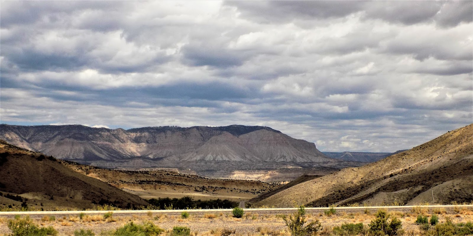
 |
| San Rafael River, San Rafael reef in the distance. |
The channel here is narrow, ten to fifteen feet wide, but the river valley is hundred of yards wide and verdant. What faced the travelers here was a massive slab of rock known as The San Rafael Reef. It was possible to penetrate this obstacle through a narrow defile called Spotted Wolf Canyon but it was impractical for a mule train that needed access to water and grazing so they followed the watercourse northwest around the rocky outcrop.
This was still an arduous trip. I followed their trail as far as I dared over a gravel track noted on the road sign simply as "county road". It was rough and subject to washouts.

Unfortunately, no real road follows the river today. The highway cuts straight through the Reef and into The San Rafael Swell. Although the early travelers had a slightly less difficult route, it was longer and still faced many similar obstacles.
 |
| San Rafael Reef |
The Spotted Wolf Canyon has been expanded by blasting into a four lane divided highway. Originally a person could reach out and touch both walls at its narrowest point.
 |
| Spotted Wolf |
Passing west of the Reef travelers of the past, and today, enter The San Rafael Swell en route to the divide that separates the eastern streams that drain into the Colorado system from those on the west that drain into the Great Basin. The Divide is about 7900 feet elevation and the desert to the east is about 5000 feet but the Swell is a series of heaves and uplifts, some of which exceed 7000 feet. It's not an easy place to travel. It is also full of seasonal or intermittent streams that flow south or southeast into the Colorado. This means that the land is useful for grazing cattle, if you know where the water is.
 |
| Sinbad's Head |
These two formations, Sinbad's Head and the Ghost Rock were named by cowboys managing cattle in this area.
 |
| Ghost Rock |
It may not look like a place you would like to run cattle but there are still plenty of allotments here.
Side canyons, slick rock and salt pans are some of the obstacles that faced the explorers and today's ranchers.

It's beautiful and inhospitable at the same time.

Imagine, spending a week or two pushing mules through here.

About three quarters of the way across the San Rafael Swell the journey becomes more of an uphill slog through rocky terrain.


Gradually, this world of rock begins to accumulate some vegetation, mostly pinion and juniper scrubs.

Near the top of the divide the traveler must decide whether to follow the original trail or take the Fish Lake Cutoff. Since it's still early summer, I will take the original trail and return on the cutoff when the weather becomes hotter and drier.

The trail now follows Salina Creek to its confluence with the Sevier River. It then follows the Sevier River Valley south.
 |
| Salina Creek near Gooseberry Road |
Through the Sevier Valley the river and trail pass through farming and grazing land.
 |
| Sevier River Near Sigurd |
After about fifty miles the river enters Marysvale Canyon.


The Sevier River is unusual in that it is one of the few rivers in the western U.S. that flows north so by following it upstream we are going south. The Sevier drains the area around Bryce Canyon and the mountains to the west including 11,307' Brian Head.

The Marysvale area is known for its gold mines and the town of Circleville is the birthplace of Butch Cassidy.

Circleville has a history of potato farming but nowadays everything seems to be hay and grazing.
 |
| Butch Cassidy's childhood home |
the trail goes past Butch Cassidy's original home.

Before reaching the Sevier's headwaters the trail turns west to cross the mountains at Utah highway 20.


From Route 20 the trail goes off onto a gravel road through an area called Bear Hollow.

I called the road gravel but a lot of it is just clay dust. It follows a small stream to some upland meadows where cattle are grazing.


At the divide the trail picks up another stream and continues southwest.


The trail rejoins the oiled road when it reaches the valley near Paragonah.

The trail continues for approximately thirty more miles to the town of Enoch where the pavement ends and it turns southwest to Mesquite, NV.


Returning from Enoch, I followed the highways to join the Fishlake Cutoff near Junction, UT. Junction has the tragic history of being the epicenter of the nuclear fallout from the Nevada A-bomb testing in the fifties. Their cancer rate for people growing up during those years is off the charts. Many people received compensation payments from the government before dying from cancer. They are still called the "downwinders".

The Fishlake Cutoff joins the main route of the Old Spanish Trail at the spot where Otter Creek joins The Sevier River near Kingston, UT. Kit Carson famously guided a party over this trail in 1848 and recalled it in his memoirs. The advantage in this route is that it takes the traveler over very high, well watered country which makes it easier on the pack animals but also ensures better access to game.
 |
| Lower Otter creek |
Shortly after heading up the creek the trail passes through Kingston Canyon.

Otter Creek was quite high and so was Otter Creek Reservoir. The Sevier, in contrast was somewhat low and sluggish. The difference is partly due to the amount of water drawn off the Sevier for irrigation but it also shows the difference in last year's snowfall on the two watersheds. This is another reason the natives and mountain men had alternatives routes.
 |
| An old millrace in Kingston Canyon |
 |
| Looking west from Kingston Canyon |
Above the canyon the creek passes through Grass Valley and the towns of Greenwich and Koosharem.
 |
| Grass Valley |
 |
| Grass Valley |
the elevation in Grass Valley is about 7000' but the trail ascends another 2000' to Fishlake.

Fishlake is about ten miles long and is fed by numerous streams that drain the surrounding 11,000' peaks. Its outlet is Lake Creek with flows into what used to be the Johnson Valley and is now Johnson Reservoir.
 |
| Lake Creek |
 |
| Johnson Reservoir |
There are a number of signs here commemorating the trail.


The outlet of Johnson Reservoir forms the headwaters of the Fremont River and the trail follows this stream for several miles.

 |
| Zed's Meadow on the Fremont |
At Mill Valley reservoir the trail turns north to cross more high country on its way to Salina Canyon.


The cutoff rejoins the main trail at the divide between The San Rafael Swell and Salina Canyon.

Traveling in this part of the country has never been easy. Scarcity of water eliminated the possibility of straight routes as did mountain barriers. It is noticeable to me that most of The Old Spanish Trail is still relative unsettled and what settlement there is consists of small towns and agriculture. Reservoirs have made this land livable but it lacks the intensive mining that brought large populations to other areas. Even the nearby national parks have not drawn a population boom to this region and maybe that's a good thing. The pioneer era is long past, but in places like this it is still possible to get a taste of what it was like when the trails were the only way to get from one place to another.


Comments
Post a Comment