The Oregon Trail, Fort Kearny to Fort Bridger
This is the first of three posts which follow the Oregon Trail from Fort Kearny, Nebraska to Oregon City, Oregon. The second is titled The Oregon/California Trail: Fort Bridger to Fort Hall, and the third is The Oregon Trail in Idaho and Oregon. I will continue to improve these posts as new information and better photos become available to me. Addition information can be found in my posts Crossing the Wasatch and California Trail- Salt Lake Cutoff. I appreciate your feedback and comments.

Right off, I want to explain that I chose the title for this post based on what I believe most people think of in regard to westward expansion. From Fort Kearny in Nebraska to Fort Bridger in Wyoming, this was also the California Trail, the Mormon Trail and, briefly, the Pony Express Route. Altogether, over half a million emigrants followed this route, mostly on foot, their belongings carried in ox or mule drawn wagons, or in handcarts. Even though a minority of them actually arrived in the Willamette Valley, the name Oregon Trail has been used so extensively it has come to represent "the way west" in the popular imagination.

I arrived in Fort Kearny on July 7, a bit tardy if I had been coming from Independence, MO or Council Bluffs, IA but I had the advantage that I could travel farther in an hour than the emigrants could in a day. The fort was built to aid emigrants and all the trails from the east joined at this location.

I was disappointed in Fort Kearny as a historic site. Only one building has been re-created while the footprints of the others have been laid out with large pegs. Perhaps they plan to build replicas one day.
 |
| Footprint of one of the buildings |
 |
| A few artillery pieces |
There is a rather sad looking wooden stockade that has seen better days.

On a more positive note, the one recreated building was the workshop which contained some interesting artifacts, including two handcarts.


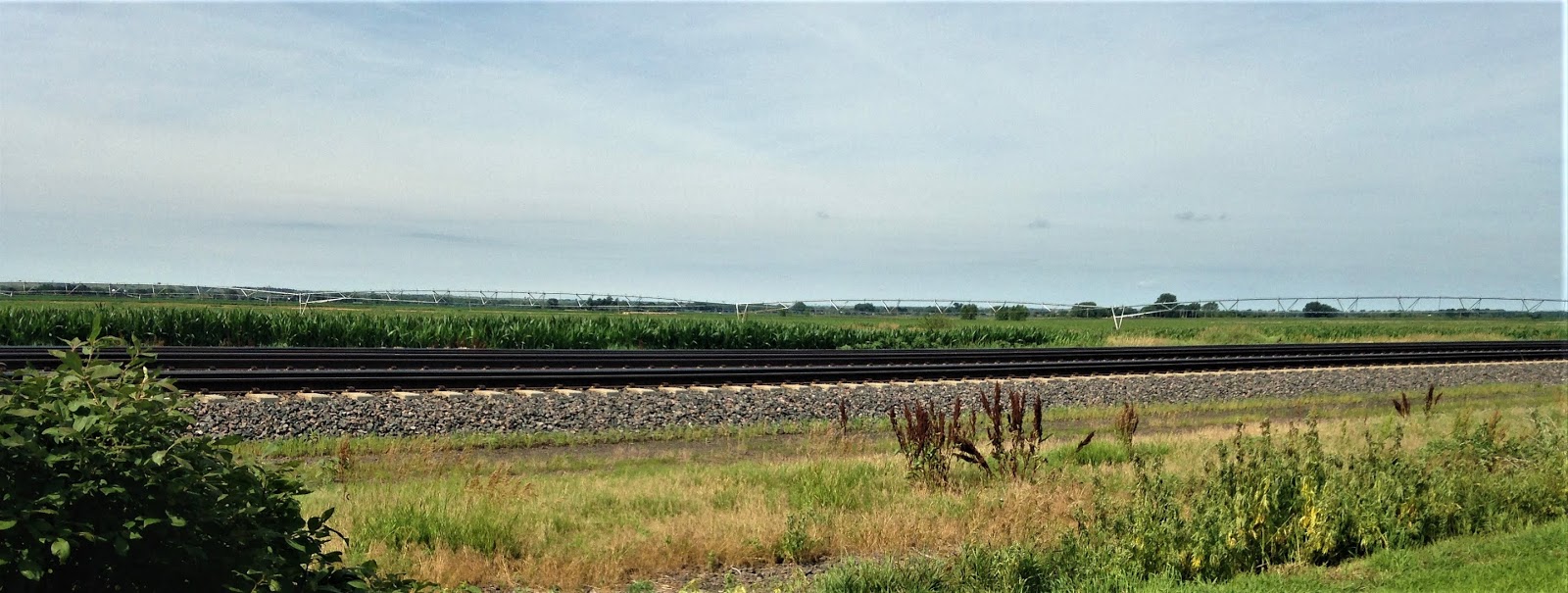
The site is totally surrounded by cornfields, typical in this area, but there was once a town here, built to "serve the needs" of the resident troops.

Not far west of Kearney (the town is spelled Kearney the fort is Kearny, go figure), the North Platte and South Platte Rivers join near the town of North Platte. This created a massive inland delta of shifting channels and sandbars and plentiful water. Much of the water is now controlled with canals which have created the extensive corn growing industry.

Mapped out in 1913, the Lincoln Highway passed through this area and was eventually replaced by US 30. To get a better feel for the countryside than is possible from Interstate 80, I followed US 30 for a fair distance but there was little change in the scenery.

Along highway US 30 is the town of Gothenburg which has a well preserved( or restored) Pony Express station.

Mail service to California was established as early as 1847 but was carried on steamships to the Isthmus of Panama, across the Isthmus by train, then to San Francisco by boat. In 1857, the Butterfield Stage Line ran mail from Arkansas, through Texas and on to California via the old Gila River trail through New Mexico and Arizona, pioneered by Kit Carson. When Texas succeeded in 1860, this route was no longer available and the Central Overland California & Pike's Peak Express Company (Pony Express) was formed to carry the mail over the Oregon trail route. "The Pony's" founders intended to develop a stage route which they put in place in 1861 along the same trail but they were bought out in 1864 and a new Overland Trail was developed via Denver and Fort Collins (but that is another story and another trail). When "The Pony" reached Fort Bridger the riders turned to Salt Lake City, then southwest to Camp Floyd and across the Great Basin to the Sierras and Sacramento. For more text and photos on this subject see my posts Crossing the Wasatch and Pony Express. The Pony Express stopped running when the telegraph line was completed in 1861 but the Overland Stage continued to carry mail, passengers, and goods.
Just past Ogallala, the trail leaves highway 30 and heads northwest along US 26. Here the distance between the two rivers increases dramatically and the trail leads to Wyoming through higher and dryer country.
Most of the literature on westward travel, and some of the signs along the way, describe the Mormon Trail as following the left (north) bank of the river while the Oregon Trail stayed on the right(south) bank. This was probably most consistent east of Fort Kearny since the Mormons were coming from Iowa while most people bound for Oregon or California began their journey in Missouri. Farther west there are many river crossings and routes would have been chosen based on trail conditions. In some places the trails converged. One of these was Ash Hollow.

Windlass Hill had a wooden winding handle(windlass) installed at its top where travelers could attach ropes to lower their wagons down the steep slope into the hollow. This area is a treasure trove of ruts, some of which have eroded into gullies.


 |
| Ruts at the top of Windlass Hill. |
 |
| Looking down into the hollow from the visitors' center. |

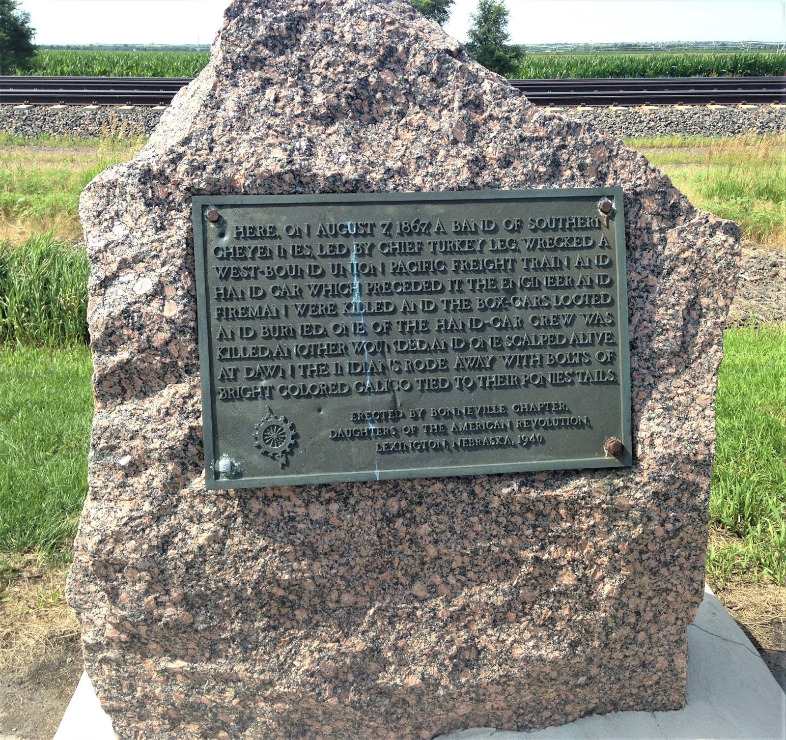
There are a lot of signs commemorating Indian battles along this route in Nebraska, a reminder of one of the hazards of the journey.
Beyond Ash Hollow the North Platte Valley is, at first, narrow, barren and rocky but as it progresses northwest it expands into a large fertile valley.


Approaching Scottsbluff travelers begin to encounter large rock formations that were named by the emigrants.
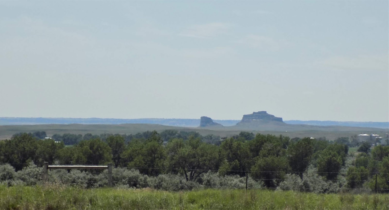 |
| Courthouse Rock |

Near most of these landmarks were Pony Express stations. Riders could change horses every ten miles but they could only rest every 100 miles.


Chimney Rock is sometimes used as a symbol of the trail.


The North Platte River through this stretch is large but not very fast moving with a lot of islands. It provides water for a large sugar beet industry in Scottsbluff.

The trail passes around the bluffs that give Scottsbluff its name. It's now a National Monument.
 |
| Scene from the top of the bluffs. The city of Scottsbluff in the near distance. |
 |
| View from the top, the straight road is the Oregon Trail. |
 |
| Looking east from the bluffs |
The trail follows a low pass and descends back into the valley bypassing today's city of Scottsbluff.


Beyond Scottsbluff the trail leaves modern day Nebraska but it continues to follow the North Platte River. Historically, the volume of water carried by the North Platte and its sister stream the South Platte is enormous. The North Platte rises in Colorado near the Rabbit Ears not far from Steamboat Springs in the northwest part of the state. The South Platte rises in South Park, southwest of Denver. Both have been "tamed" by dams and canals but both were important routes for westward settlement. Just as the North Platte supported the emigrants, the South Platte led prospectors to the Colorado gold fields.
 |
| North Platte River near Scottsbluff, Nebraska |
The next important landmark on the trail is Ft. Laramie, the first stop where travelers could get supplies and repairs nps.gov/fola. Established at the junction of the Laramie and North Platte Rivers, this outpost was first a trading post run by former fur trappers, then taken over by the army in 1849 and built up into a major installation. After my experience at Fort Kearny, I was prepared to be disappointed with this site but I found it very worthwhile.


Many of the buildings here have been restored, while others continued to be occupied after the fort was decommissioned in 1890. It is now a mixture of ruins and restored buildings.

The only disappointment was the lack of any remnant of the original trading post.
 |
| The Suttler's store |
 |
| The Surgeon's residence |
 |
| Married Officers' Quarters |
The Bachelor Officers' Quarters is the oldest original building in Wyoming and was nicknamed "Old Bedlam" because of the wild parties held there.
 |
| Old Bedlam |
 |
| The Stockade (jail) |
 |
| The Magazine |
 |
| Cavalry Barracks |
There is no defensive fortification here, the main duty of the troops was patrolling the trails. This post was vital during the Black Hills gold rush when the preferred route to the Black Hills was through Ft. Laramie. Besides prospectors (in violation of treaty), a stage route ran from Denver to Cheyenne, and on to the Black Hills, to the displeasure of the Lakota Nations. This was also a Pony Express and Overland Stage station.
Not far from Fort Laramie is Register Cliff a favored camping area next to the river where many passersby carved names and dates into the soft cliffs.


Some of this graffiti came long after the pioneers.


This is a beautiful spot but probably over run by mosquitoes in the absence of a stiff breeze. Fortunately, there's almost always a stiff breeze in Wyoming.

Register Cliff was also a Pony Express station.

A little further west, near Guernsey, WY are some dramatic ruts carved into the sandstone surface.

Although this was part of the trail, the ruts were greatly enlarged by heavy freight wagons,


After the Guernsey Ruts, I left highway US 26 and hopped on Interstate 25 to Casper. this is a surprisingly pleasant stretch for Interstate travel, passing through rolling grassland with a mountain backdrop. It led me to the opinion that there are still more cows than people in Wyoming.

Fort Caspar began as a ferry then a bridge on the North Platte but soon increased in importance as a military outpost www.fortcasparwyoming.com. If you follow this link, click on "site history".

The reconstruction by the WPA is excellent as is the bookstore in the visitors' center.
 |
| Barracks and parade ground |
 |
| officer's quarters |
 |
| Barracks and mess |

 |
| Mormon Ferry |

Fort Caspar probably saw its heyday in 1857 when it served as a supply line and staging point for troops during the "Mormon Rebellion" (see my post Pony Express) .
Beyond Casper, the trail leaves the North Platte River and follows the Sweetwater, but not before passing a series of dams built to provide a consistent water supply for Wyoming agriculture.

Independence Rock, on the Sweetwater, was so named because travelers west aimed to arrive there by Independence Day.

Those who came along late were at risk for early storms farther along the trail. Among those who met that fate were the Martin Handcart Company who were forced to seek refuge near Devil's Gate during an October blizzard.
 |
| Devil's Gate |

The ranch at Devil's Gate is now owned by the Church of Jesus Christ of Latter Day Saints and along with its visitor center it provides a starting point for handcart treks for the hardy.
 |
| Ranchland upstream from Devil's Gate |
Split Rock is another notable landmark along the Sweetwater.
 |
| Split Rock |

From Split Rock it's a long stretch to South Pass and the road passes through Wyoming's wild horse range. Luckily I passed two groups, probably stallions with their mares and foals, but only one was close enough to the highway to photograph.

This is a lot of open country with the Wind River Mountains in the background.

Red Canyon, near Lander is one of the oldest sections of the trail, long used by Native Americans and trappers. It is now a wildlife refuge and the highway skirts along the edge.


South Pass is often described as a gradual assent, easily managed by wagons. That may be so, but there is a lot of up and down hill travel that would have been strenuous. at the top you reach the Great Divide Basin which is vast and almost flat. There is no really noticeable summit here but eventually you begin a gradual descent which is not at all difficult.


The above shots were taken near South Pass City, an old mining town.
Descending south Pass brings you into the Green River drainage on the Pacific side of the Continental Divide. You pass the Lander Cut-off which is not paralleled by any highway and leads directly to Fort Hall (Pocatello, ID) via Afton, WY.

Here the Wind River Mountains are again in the background.
 |
| Wind River Mountains |
Traveling southwest, the first tributary to the Green River is the Big Sandy River. Here, it's not big because it's dammed farther upstream.

 |
| Big Sandy River |
there are several areas here where wagon ruts are clearly visible. Faintly visible in the distance is Church Butte, a landmark near Fort Bridger.

 |
| Church Butte |
Where the Big Sandy flows into the Green River the Mormons built a ferry to get wagons across the difficult crossing.

 |
| Green River near Lombard Ferry |

After crossing the Green River (which is heading toward Flaming Gorge) the trail continues southwest to the historic town of Granger with its Pony Express station.

From Granger it's only a short trek to the Blacks Fork River and Fort Bridger. To the south the Uinta Mountains dominate the view.

 |
| Fort Bridger |
To continue following me on the emigrant trails, check out my additional posts. Bear River follows the Oregon trail from Fort Bridger to Fort Hall and The Oregon Trail in Idaho and Oregon continues to Oregon City at trail's end. Crossing the Wasatch follows the Mormon Trail and Pony Express to the Salt Lake Valley and California Trail-Salt Lake Cutoff takes you to Granite Pass on the way to California. Thanks for following me.


Comments
Post a Comment