Day 2 - Colorado
It seems like it immediately gets greener when you cross the border from Utah into Colorado. This is at least partly due to a bend in the Colorado River which creates a wide flood plain that the farmers have taken advantage of by developing extensive irrigation systems. The first town on Route 50 is Fruita, then comes Grand Junction, then Fruitville, so it's obviously a lush valley.
the picture above was taken from the Colorado National Monument looking across the Fruita Valley toward Utah. The background looks almost bleached compared to the foreground.
The "Grand Junction" that gives the primary city here its name is the joining of the Colorado River with the more southerly Gunnison. Everything here is "Grand", Grand Valley, Grand Mesa, I guess the founders liked their location. The adjective than I cannot avoid for this place is "gentrified" and since I was here last it has even become pretentious. I took a back route from the national monument into Grand Junction and passed several wineries and developments of McMansions interspersed among the "horse properties". The core of the city has retained a lot of its historic buildings but it hasn't done much to maintain them.
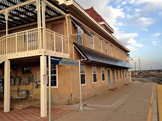
The Old Denver and Rio Grande Depot looks pretty good from this side. It has some shops in it but is partly boarded up. Amtrak still stops here and the freight traffic is vigorous. I may have to try one of these routes to see just how bad it really is trying to get somewhere by train.
Last time I was in Grand Junction, about seven or eight years ago, it seemed like a fun place. Several blocks of downtown were traffic free, there were outdoor restaurants and buskers on the street corners. Today we would probably call that "hipster". Unfortunately, hipster seems to be the pioneer species for gentrified.
Continuing east on Highway 50, the road continues to follow the Old Spanish Trail up the Gunnison drainage but the rail line follows Interstate 70 to Denver. The towns of Delta and Montrose appear tidy and prosperous and it is obvious their past is largely agricultural rather than mining related. Montrose especially has retained a pleasant downtown area with no obvious signs of decay.
Not far from Montrose begins the Black Canyon of the Gunnison National Park, a remarkable piece of natural engineering. It's one of the oldest canyons in the world and was caused by erosion of extremely hard igneous rock. That's why it's black.
It's also nearly sheer in spots and some of the overlooks are scary. It's unfortunate this place doesn't get visited a lot, it's really remarkable.
Almost as interesting as the canyon itself is the fact that a tunnel was drilled through this rock to bring irrigation water to the valley to the south.
After leaving the Black Canyon and returning to Highway 50, you move away from the river and travel through an area of large ranches until the road swings back to the Curecanti National Recreation Area.
The Curecanti is a series of reservoirs created by several hydroelectric dams. The whole area is incredibly scenic and the lakes are generally small fishing and boating lakes, not vast playgrounds like Lake Powell or Lake Meade. The Largest is Blue Mesa Lake.
Not far east of Blue Mesa Lake is the town of Gunnison which I found pleasantly "ungentrified" in spite of the fact that it's a college town and the gateway to Crested Butte ski area. The road now stops following the Gunnison River and continues up the valley of one of its headwaters, Tomichi Creek. This is generally rolling country of grass and scrub oak but the meandering of the creek creates meadows which are dotted with small ranches and grazing cattle. This continues to within the last few miles leading up to the Continental Divide at Monarch Pass where the road is steep and winding and prone to year round snow.
Remembering that this is part of the Old Spanish Trail, I can't help but picture Franciscans in robes and sandals herding donkeys over this pass.
The east side of the divide contains the headwaters of the Arkansas River which, once it reaches the prairie, parallels one of the longest stretches of the Santa Fe Trail. The Arkansas starts out as a small trout stream .
Of course it's joined by tributaries and picks up steam as it grows. By the time it reaches the first towns it has become a popular floating and fishing river.
In contrast to the Gunnison side of the divide the economy here is dominated by recreation. Cabins, trailers, RV parks, zip lines, river companies and shuttles, all litter the banks of the river for miles.
Finally the road reaches a canyon area that is too rugged for habitation and it's just a pleasant drive beside the river.
It's surprising how quickly the foothills transition into prairie and by the time you reach Pueblo you can no longer see the mountains behind you. After a while the open range gives way to irrigated agriculture, mostly pinto beans and alfalfa, with the exception of Rocky Ford which is known for its melons. I was surprised to see so many businesses closed down in Rocky Ford, which is a good sized town but my eyes were opened when I reached La Junta, my destination for the day. The first business that greeted me there was a WalMart.
Some further research has shown me that my route from Gunnison over Monarch pass was not considered part of the Old Spanish Trail. The North Branch turned south near present day Gunnison and crossed the continental divide at North Pass, continuing to Santa Fe via the Rio Grande drainage. The map above shows The Old Spanish Trail (North Branch) in purple, my route over Monarch Pass in green and The Santa Fe Trail in red. Map courtesy of d-maps.com.


Great photos!
ReplyDelete