The Bear River Massacre
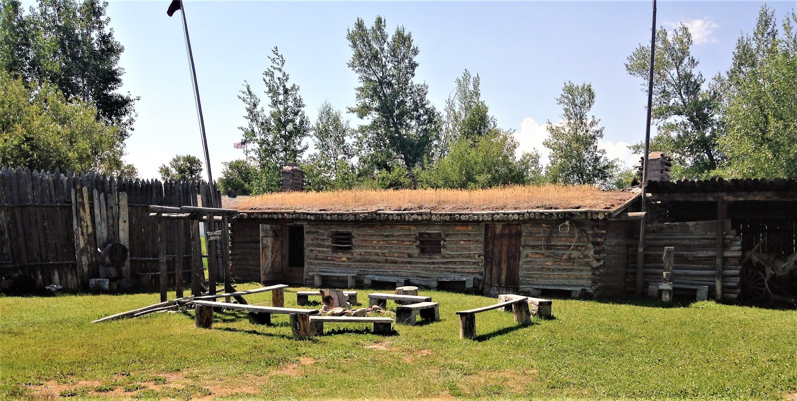
Westward travelers followed a variety of trails from the 1830's until the completion of the transcontinental railroad in 1869 but with the exception of Mormons bound for Utah, they nearly all stopped for refitting and rest at Fort Bridger in Wyoming Territory and Fort Hall in what is now Idaho. Fort Hall was established in 1834 on bottom land adjacent to the Snake River near present day Pocatello, Idaho. It's founder was N. J. Wyeth whose aim was to create an independent fur trading company. By 1934 the fur trade was already in decline and competition (some of it unfair) from the already established Rocky Mountain Fur Company and the Hudson Bay Fur Company forced Wyeth out of business and he soon sold out to the Hudson Bay Company.
 |
| Fort Hall replica Pocatello, ID |
Fort Hall was built to be a trading post, not a military installation and the way it is set up reflects that.
Living accommodations were minimal but much space was given to works shops and storage for trade goods. As Oregon Trail traffic increased during the 1840's, the fort was enlarged and included a blacksmith shop and carpenter shop. The original stockade was covered by white adobe by the Hudson Bay Company.
 |
| Interior courtyard of fort Hall, blacksmith and carpentry shops in the rear. |
The first trading partners were the few remaining trappers and Indians of the Shoshone and Bannock tribes of the upper Snake River region but emigrants were soon to follow. Following the Bear River Divide route pioneered by General Ashley of the Rocky Mountain Fur Company, the first emigrants from the east to arrive at Fort Hall were the members of the Whitman-Spalding Mission bound for Oregon Territory in 1836. These were followed by a California bound party in 1838 that was guided by mountain man Thomas Fitzpatrick who left them at Fort Hall with his advice not to continue. They made it on their own across the Great Basin but their route was not popular in the future.
 |
| Store rooms and accomodations |
Hard economic times in the east in 1839 stimulated interest in Oregon and by 1841 the wagon trains were rolling. East of Fort Hall the last opportunity for emigrants to resupply was Fort Laramie on the North Platte River so in 1843 former trapper Jim Bridger set up a trading post at Fort Bridger on Black's Fork of Green River in an area of good grazing and ample fresh water. This was just west of the spot where the trail crossed Green River and is between modern day Evanston, WY and Green River, WY.
 |
| Fort Bridger replica |
Like Fort Hall, Fort Bridger supplied blacksmithing and carpentry services but early visitors reported disappointment at the scarcity of other supplies. The shabby appearance of the fort was also disappointing.
 |
| Blacksmith shop and store |
 |
| Courtyard with fur press |
In spite of its shortcomings, Fort Bridger became an import stop on the trails because this was the point where the Mormon, California, and Oregon Trails diverged. Previous to 1846 westward travelers headed northwest from Fort Bridger, crossed the Bear River Divide and followed Bear River to Red Rock Pass where they crossed into the Snake River drainage and on to Fort Hall.


In 1846 the Hastings Party traveled west from Fort Bridger to Echo Canyon, then on through Weber Canyon into the Salt Lake Valley. They were followed by the Donner Party which followed an alternative route through East an Emigration Canyons. These routes are more thoroughly described in my post "Crossing the Wasatch". After 1847 the Donner Route became the last leg of the Mormon Trail and the Weber Canyon route was followed to Fort Hall by travelers to California and Oregon. For today's convenience the Bear River Divide route is called the Oregon Trail while Weber Canyon is the California Trail even though they have the same destination. In future posts, I will describe how the trails separated after Fort Hall en route to California and Oregon.
 |
| Coming into Echo Canyon from Fort Bridger |
I traveled to the replica of Fort Hall in Pocatello while researching this section of the Oregon Trail and was surprised to learn about an event I had never before heard of, the Bear River Massacre. I have given a fairly detailed description of Forts Bridger and Hall to emphasize that this section of trail was heavily traveled. It was also in the center of the traditional lands of the Northern Shoshone nation who occupied an area from the Bighorn Basin in the east to the Snake River Valley in the west where they were neighbors of the Bannock people.

The Shoshone occupied a vast area but it was not all equally productive. During the Wyoming cattle boom of the late 1870's and 80's it was estimated that cattle herds required approximately forty acres per cow to sustain them. The emigrants on the trails put extensive pressure on the area's resources and were often in direct competition with the Shoshone. One future Oregonian described conditions on the trail as stripped of vegetation for an area four miles wide and hundreds of miles long. This was the impact faced by the Shoshone. It was to get worse.
The California and Oregon emigrants were passing through but the Mormons were here to stay. In 1859, they began settling in Cache Valley at present day Logan, UT, and in 1860 they established a community at Cub River in present day Franklin County, Idaho. Franklin county contains most of the Bear River Valley as it crosses Idaho.
 |
| Bear River near Preston, ID |
These are verdant, well watered valleys coveted by the Mormons for agricultural development but important to the Shoshone as sources of game and good places to spent the winter months. It's no surprise that conflicts occurred between the Indians and the settlers in spite of policies of peaceful coexistence recommended by Brigham Young and the Shoshone chief Washakie (1810-1900).
The situation was aggravated by discovery of gold in Bannack, Montana in 1862. The Montana Trail had been in use for several years carrying supplies from Salt Lake City to its northern end at Fort Benton on the Missouri River. It was especially important in the summer months when the Missouri waters were too low to support steamboat transportation from the east. The Bannack strike caused a big increase in traffic on this trail as miners, camp followers and supplies rushed north to the gold fields. On its way to Montana the trail traversed Cache Valley and crossed Bear River just north of present day Preston, a popular camping spot of the Shoshone.
At the beginning of the Civil War, Federal troops were brought to Fort Douglas in Salt Lake City to help maintain peace on the frontier. For the most part, they were unhappy with the assignment and would have preferred to be in the east fighting rebels.

In January, 1863 they were deployed to Cache Valley and Bear River to punish the Shoshone for the many incidents that had occurred in the area. Conditions among the Shoshone amounted to starvation throughout 1862 and driven to desperation they had faced many violent clashes with settlers and trail travelers. Requests for relief supplies made by the Indian agents to the federal government had gone unheeded and most of the local settlers were unsympathetic. Basically, the army was sent to settle the "Indian Problem".

The results were predictable. The Battle of Bear River saw fourteen troopers killed while over 220 Shoshone were reported killed at the first count. This of course included women and children. Later reports from Franklin County residents indicated much greater Indian losses. Then the process began of rounding up the Shoshone and placing them in a reservation near Fort Hall where they were later joined by the Bannock following the Bannock War of 1870.

Today the battlefield can be viewed from an overlook with signs describing the sites of the various incidents.

In these pictures the river is mostly obscured by Russian Olive trees which are the grayish vegetation in the mid-ground.

Downstream from the site are
a highway marker and a monument.

The river itself is better viewed from the highway.

The battle was also memorialized in a mural in the Preston post office, a fine example of New Deal public art.

This posting is a sidebar to the story of the Oregon Trail that I never expected to write. It also opened up my discovery of the Montana Trail which I will add to my list of future travels. Today, the Bear River Valley where this sad episode occurred, is dotted with a few small towns and is filled with large farms. The whole population of Franklin County is about 13,000 while Bannock County, site of the Fort Hall Reservation, contains over 82,00 people and is home to Idaho State University. The reservation itself is surrounded by irrigated potato fields in a vast display of industrial agriculture while Franklin County is still relatively pastoral. Maybe the Shoshone have achieved some level of retribution by introducing casino gambling to this religious and conservative part of white America but they must have ongoing regret and sadness over what they have lost.


Comments
Post a Comment